Categories
news

CameraGPS 1.2

CameraGPS 1.2 is a big update. I toyed with the idea of calling it version 2.0; it’s that big.

CameraGPS -- geotagging
Geotagging

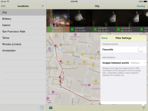
The “marquee” new feature is built-in geotagging. When you open a trail, you can see any editable pictures that were taken around the same time. Pins show where the trail indicates your pictures were taken. You can then select the images you want to tag and add the location to them. The location can either be the nearest “real” location — i.e., an actual recorded track point — or CameraGPS can interpolate between the two nearest points.

CameraGPS - Export trail
Export trail

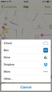
Of course if you want to continue to use your favourite geotagging app you can. Version 1.2 includes support for the new “extensions” that Apple introduced with iOS 8, allowing you to export your GPS trails to any supported cloud service. Of course, Box and Dropbox are still supported. We’ve also tested exporting to Google Drive and iCloud Drive. All you need to do it install the services app.

Note: You’ll need the latest version of the Box app (3.5.2 at the time of writing) for it to work reliably with that service.

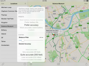
In addition to all that, there’s a host of smaller changes and improvements. Some of the more visible include the “Low battery” notifications now include the ability to stop recording without opening the app and support for the latest Apple devices (iPhone 6 and 6+ screen sizes, 64-bit builds). Of course there are always minor tweaks and fixes.

A lot of work has gone into this release and we hope you like it. It’s a free update for existing users and the same bargain price for everyone else. It’s currently with Apple for review and hopefully we be out soon.

Categories
news

CameraGPS 1.1.1

I’ve seen a few reports of CameraGPS randomly stopping recording trails. This is both disappointing and confounding. Disappointing because, obviously, this is the whole point of the app. And confounding as I have never seen it happen myself, despite using the app most days.

So, in this new version of CameraGPS, I have made a number of speculative changes that should either improve reliability on their own or at least give better information about how to track down any problems if they do occur.

An incomplete list of changes looks like this:

  • Turn off trail “pausing.” Your iPhone typically turns off recording when you stop moving for a period of time. It seems to be unreliable resuming again when you start moving. This may reduce battery life but should stop CameraGPS “randomly” stopping recording.
  • Better save state when CameraGPS goes into the background. This means that in low memory situations it should more reliably re-launch.
  • Correctly show in the UI when “Significant update tracking” is not available on the current device
  • Automatically add a log file when emailing support
  • New feature: split trail. When you are recording, there is now a “scissors” icon that allows you to create a new segment in your trail. (Previously you could achieve the same effect by stopping and starting recording.)
  • Rename trails in the iPad version

I hope these changes have the desired effect. If not, please contact me using the Support button in the About screen of the app. I can’t fix bugs that I don’t know about!


Categories
support

Using CameraGPS when offline

I’m going to create an FAQ for CameraGPS now that it’s becoming clearer what the most frequently asked questions are! The most frequent so far have all been around how it works when away from a good data connection. So here are few of the obvious questions. Please ask any more you have in the comments.

Can I record trails when I have no data connection?

Yes.

Will I still be able to see the map when offline?

Maybe.

When you view a map on your iPhone, iOS remembers (caches) as much of the map as it can. So, if you look at a map and then switch on AirPlane mode, you will still be able to move around a little and zoom in.

The same thing happens when you start a trail in CameraGPS with a strong data signal and then spend the rest of the day away from the cell network. Parts of your trail that were visible when you started the trail will probably be visible even when offline. New parts will not. Also, you won’t be able to switch views and expect to see it update. Your best bet at getting the most data available offline is to use the normal map view. As you would imagine, using the satellite view takes up more space.

How big is this offline cache?

The area available varies depending on a lot of factors, few of which you or I can control. To give you some idea, I was able to cache a lot of the Bay Area (the City, Berkeley, the southern part of Marin) when I was there a couple of years ago.

Can I tell CameraGPS to remember bits of the map in advance so it will be available when I’m offline?

As far as I know there is no way for me to do this. The best I can offer is suggesting that you view the area you’re planning on visiting shortly before you lose your data signal.

Can I save to Dropbox or Box when offline?

No. You should get an error message saying so.

Is there anything else that won’t work?

It won’t be able to copy your data to iCloud — though it will upload the data when you later get a data connection.

And it won’t be able to correctly name any new segments of your GPX trail (you can see them in the “Options” screen). Again, it should fill in the gaps once you have a data connection.

Categories
news

CameraGPS 1.1

CameraGPS on the iPadThe first feature update to our newest app, CameraGPS, is now with Apple awaiting review. Hopefully it will be available to download shortly.

In addition to the usual minor fixes and refinements, CameraGPS 1.1 has two main features:

  • Export your GPX trails to Box as an alternative to Dropbox
  • Now a Universal app, working both on the iPhone and the iPad
  • Syncs between all your devices using iCloud

Yes, I know that’s three bullet points. The iCloud syncing was there in version 1.0 but now, with the iPad support, it’s actually useful!

Box has become increasingly popular recently, especially with companies rather than individuals, and it’s always good to have extra options.

Personally, I don’t use the iPad version to record the trails, but I find it useful to be able to view them on the larger screen of the tablet. Sometimes you need to wait a while before all your devices are in sync. This, unfortunately, is outside our control (there’s no way to even show a progress indicator or even a hint that there is data to be downloaded). However, what I can say is that it’s worked pretty well for me.

I hope you like the new features. Please let us know what you think.

Categories
news

CameraGPS 1.0.1

Before release I found a couple of minor bugs in CameraGPS — not enough to stop the release but enough that I wanted to fix them before many people managed to find them.

Hence: CameraGPS 1.0.1. It’s now available in the App Store. If you’ve not already bought a copy, what are you waiting for?

Categories
news

Introducing CameraGPS

London, United Kingdom – Wandle Software Limited is pleased to announce the immediate availability of its latest app for iPhone: CameraGPS, a GPS logger for people who want to geotag their photographs.

CameraGPS - Map
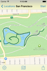
Designed exclusively for iOS 7, it has an interface focused on the only two things that matter in a GPS logger to photographers: recording a trail and exporting it to applications that can make use of them, such as Adobe Lightroom and Apple Aperture.

Unlike many other apps there’s no need to sign up for third party fitness websites or enter superfluous information. Just enter the trail name and tap “Start” to begin recording a trail.

CameraGPS runs in the background and has some simple presets so you can get the compromise between battery life and accuracy that works for you.

Once your trail is recorded you can make minor edits — CameraGPS helps you identify any suspect points — and save straight to Dropbox in the industry-standard GPX format. No need to email it to yourself, though you can if you like.

By avoiding clutter and complexity, CameraGPS keeps out of your way and allows you to focus on your photography.

It is available immediately on the App Store for $1.99, £1.49, €1.79 or your local equivalent. You’ll need a device that supports iOS 7 and has a GPS chip (iPhone 4S and above).

This follows the recent relaunch of Rootn Tootn, the baby feed timer and diary app without all the pastel blues and pinks, as a free app with an in-app purchase.